Aeronautical Operations
Air Power
From the outset, the command staff of the DTC/C-AMA wanted air support to be an integral part of the training experience in the desert. Although planes were used from virtually the beginning of the DTC/C-AMA, an official air support command was first established at Camp Young. Subsequently, four other divisional camps received air support commands (Meller 1946). Unfortunately, like every other type of equipment at the DTC/C-AMA, airplanes were in short supply.
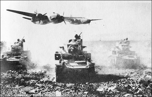
In June 1942, the Second Air Force assumed responsibility for air operations at the DTC. Headquartered at Camp Young, the Second Air Force also assumed responsibility for the many airfields throughout the DTC/C-AMA area (U.S. Air Force Historical Division n.d.a :1). In the early months, air units were under the direct command of the AGF and were not allowed to act in their usually autonomous roles. Air squadrons were primarily assigned supporting roles to the ground contingents, providing tactical support and generally creating a realistic combat environment (Blake 1987:23). During maneuvers and other training operations, planes were flown low over the troops in order to prepare them for strafing in actual combat.
Airdrome detachments were stationed at various airfields and were under the command of the III Tactical Air Division at Camp Young (U.S. Army Air Corps 1944 :1). The III Tactical Air Division was given the responsibility of assisting in the training of tactical air units. In addition to training, however, each unit was in charge of maintaining its airfield and had little time for anything else (U.S. Army Air Corps 1944 :3).
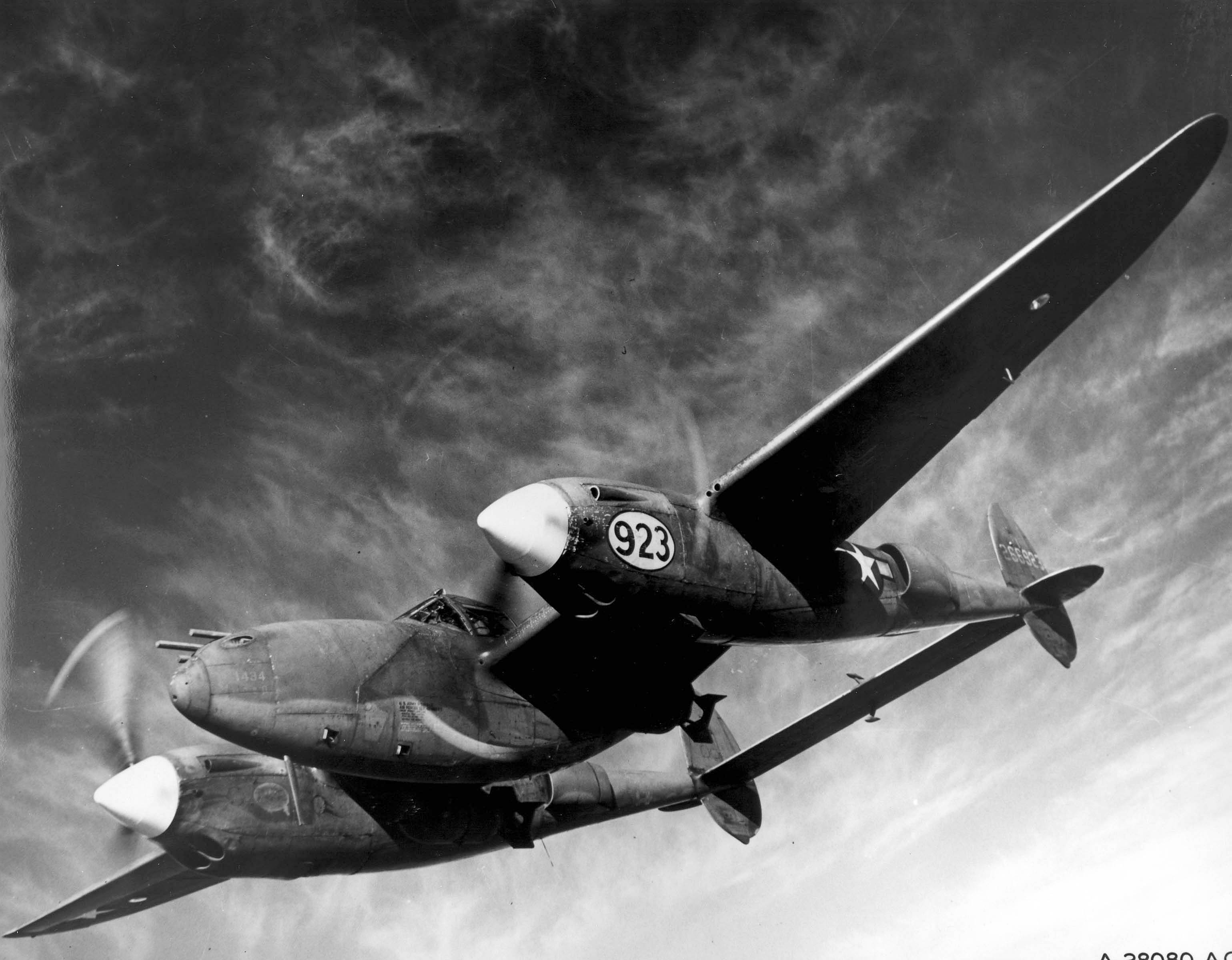
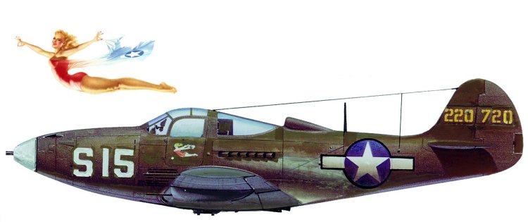
All manner of airplanes were used, particularly L-1 and L-4 Piper Cubs for surveillance. Patton himself used his own private plane, a Stinson Voyager, or "flying jeep" as the planes were also known. C-50 cargo planes were used in several instances, including for troop supply during maneuvers. Supplies, including ammunition, were parachuted to waiting troops by the C-50s, with mixed results. Light bomber-ground attack A-20 Havocs were stationed at Blythe Army Air Field, as well as at Camp Essex. P-40 Warhawks and P-38 Lightnings are also known to have been used at the DTC/C-AMA, as were B-24 Liberators.
There were four main army airfields in the DTC/C-AMA: Rice, Shaver's Summit, Desert Center, and Thermal. In many other locations, the army used existing civilian facilities, such as the airport in Boulder City, Nevada. In other cases, the army established facilities that were subsequently taken over for civilian use after the end of the war. For example, an airfield built in Palm Springs by the army became the city's municipal airport after the war (Weight 1977).
One of the more visible makeshift airfields was adjacent to Essex Divisional Camp. This field, unlike the other temporary strips, was designed to handle aircraft as large as A-20 Havocs. The flying surface was 4,500 feet long and 111 feet wide, and consisted of a light bar-and-rod steel landing mat. Shoulders measuring 120 feet wide were constructed with compacted sand, and the taxiways and warm-up ramps were made of soil cement and desert mix. The area was graded and was watered down with commercial trucks, which received water from the Santa Fe Railroad well at Fenner (U.S. Army Air Corps 1942 :G1-4C-4).
Airports, Aerodromes, and Airstrips:
- Chiriaco Summit Airport (L77): East of DTC headquarters Camp Young. Open to public access today, and facilitates visits to the General Patton Memorial Museum.
- Desert Center Army Airfield (CN64): Open to public access today. Equipped with O-52s, L-1s, L-4s, B-25s, P-39s and P-40s during the war.
- Coxcomb Divisional Camp Airstrip: Located across CA Hwy 177 east of Camp Coxcomb. Oriented north-south.
- Camp Iron Mountain Army Field: Today's Iron Mountain Pumping Plant Airport (72CL).
- Rice Army Airfield: Consisted of two 5,000 foot runways with numerous dispersal pads. Today, it is the site of the Rice Solar Energy Project.
- Camp Essex AAF: Served the divisional camp. Currently closed.
- Goffs Airstrip: Triangular layout, still faintly visible today.
- Camp Ibis Airstrip: Located across US Hwy 95 west of the camp.
Landing Strips
Several sand and gravel landing strips existed throughout the DTC/C-AMA, usually measuring 1,000 feet long and 100 feet wide. Many of these runways existed prior to the activation of the DTC/C-AMA, although several were constructed for army use. During maneuvers, landing strips were established in a variety of locations. The strips used in the DTC/C-AMA had the following names:
- Bagdad
- Cadiz
- Calipatria
- Chocolate Mountains (east end)
- Chuckwalla Mountains
- Connor
- Coxcomb Camp
- Ford Well
- Freda Station
- Goffs
- Granite Mountains
- Harveys
- Heron
- Hopkins Well
- Hyder
- Ibis
- Imperial County Airport
- Iron Mountain
- Little Chuckwalla Mountains
- McCoy Springs
- Milpitas Wash
- Palo Verde
- Piute Mountains
- Plosser
- Salome
- Searchlight
- Smiley
Aircraft Gallery
The air-ground training conducted in CAMA was considered some of the most satisfactory training in the United States. Air crews practiced bombing and gunnery on several ranges spaced throughout the DTC/CAMA. The low-flying, twin-engine A-20 Havoc attack airplane was perhaps the most frequently encountered by ground troops. Because of the presence of these aircraft, small units learned the importance of camouflage, dispersion, and the digging of slit trenches.
Douglas C-47 Skytrains were common sights in many places in the DTC/CAMA. The P-39 Airacobra, P-40 Warhawk, and P-38 Lightning were also known to have been used at the DTC/CAMA.
Official Airdrome List (May 4, 1943)
Source: White, Major Gen., Desert Training Center, General Information, obtained at NARA, Archives I, Records Headquarters AGF, RG 337
Related California Marine Air Stations
Not every wartime aviation site connected to the desert-training story lay inside the DTC/C-AMA itself. Santa Barbara and Santa Ana/Tustin belonged to the wider California military aviation network that trained, refreshed, and organized Marine air groups while the desert airfields were active.
Marine Corps Air Station Santa Barbara
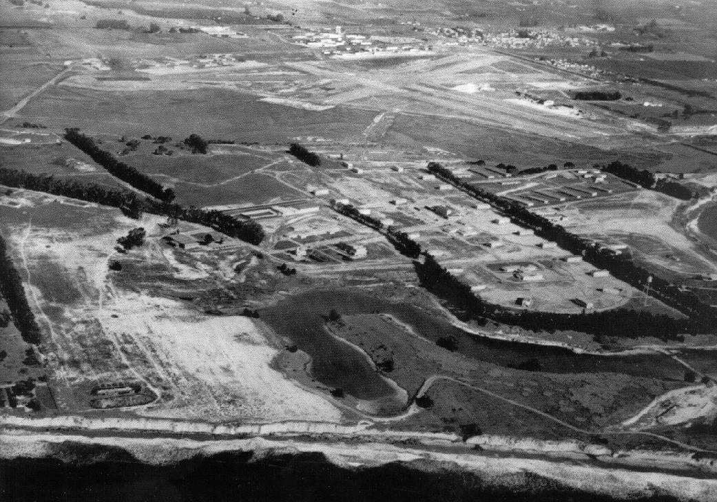
At Goleta, north of Los Angeles, the Marines took over the improved municipal airport in 1942 and quickly turned it into a Marine air station. Early conditions were rough enough that the station earned the nickname The Swamp, but Santa Barbara soon became a productive wartime base where Marine air groups trained, rotated, and reorganized. The histories you supplied describe it as both a MAG station and, later in the war, an important carrier-group preparation center.
The site is especially useful for understanding how West Coast aviation support extended beyond the desert itself. Corsairs, Wildcats, Avengers, utility aircraft, and returning combat squadrons all passed through Santa Barbara, and the surviving aerial and layout views make the scale of the station legible in a way that complements the more improvised DTC landing strips.
Sources: California State Military Museum: Marine Corps Air Station, Santa Barbara; text excerpts attributed there to M.L. Shettle, Jr. and Justin Ruhge.
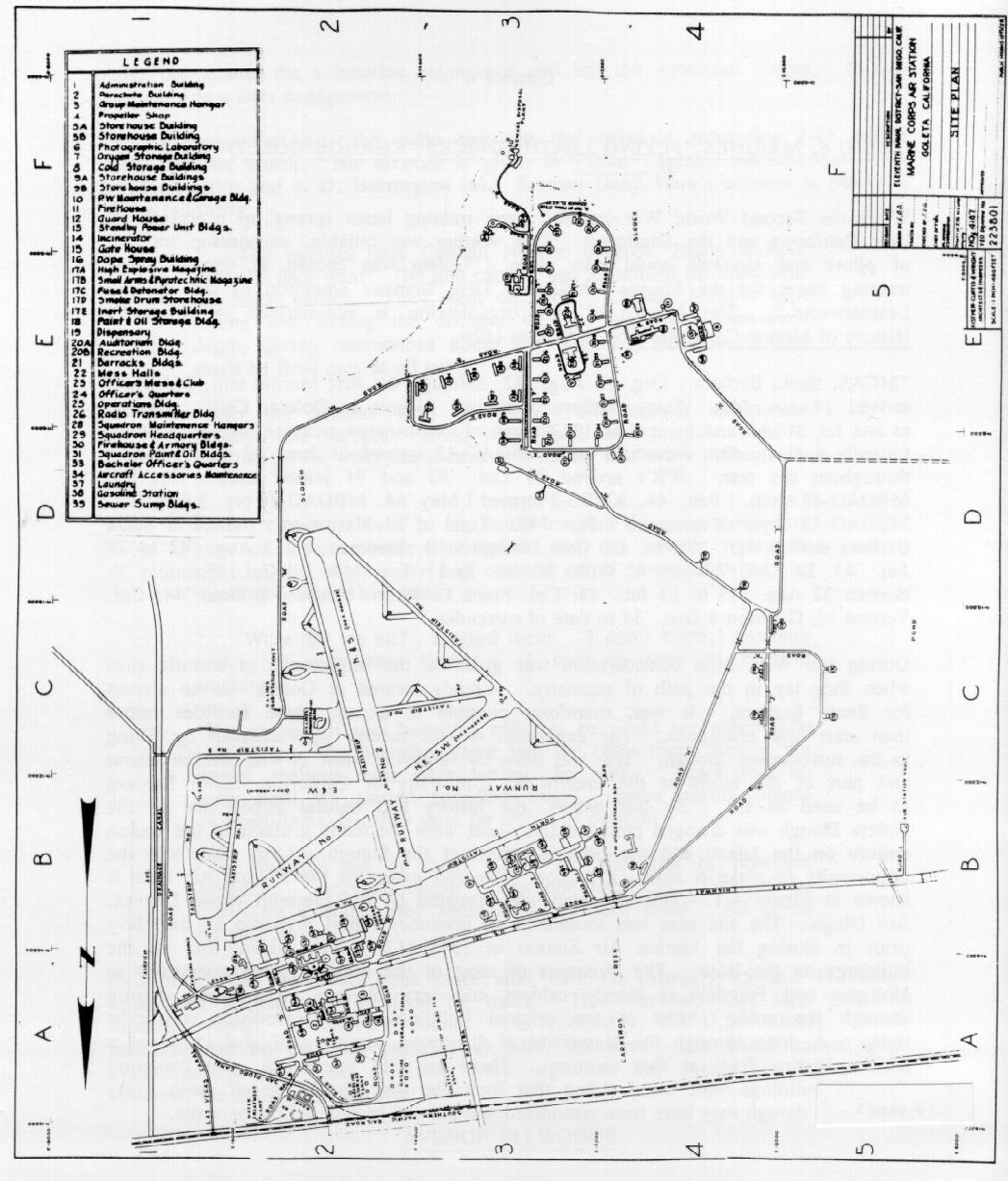
Marine Corps Air Station Tustin / NAS Santa Ana
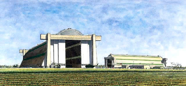
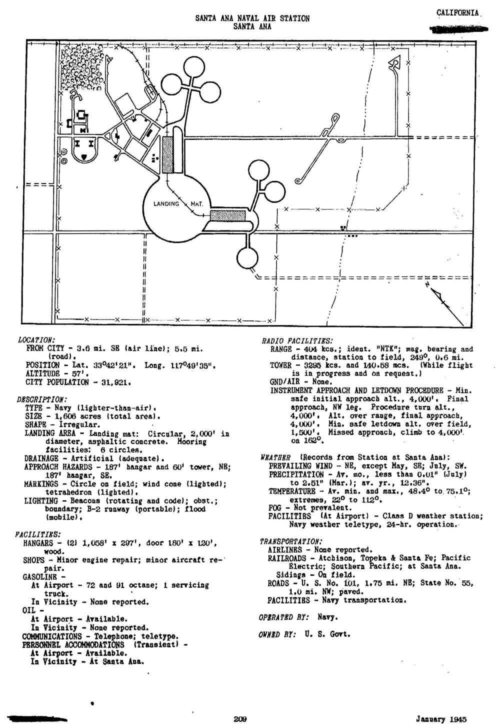
Tustin began as Naval Air Station Santa Ana, a 1942 blimp base built for coastal patrol and dominated by two giant wooden lighter-than-air hangars. The wartime Santa Ana layout centered on a circular landing mat and a ring of mooring pads, showing a very different aviation landscape from the fighter and attack fields used in the desert.
After the war the station changed hands and missions, eventually becoming Marine Corps Air Station Tustin, the Marine Corps' major West Coast helicopter base. That long afterlife makes Tustin relevant here: it illustrates how southern California's wartime aviation infrastructure outlived the DTC and evolved into later Marine aviation facilities rather than simply disappearing.
Sources: California State Military Museum: Marine Corps Air Station, Tustin; page text attributed there to Paul Freeman, M.L. Shettle, and Justin Ruhge.
Aviation Archaeology Resources
For those interested in further research regarding abandoned runways and historical aviation markers, we recommend the following archives:
Maintained by Paul Freeman, this massive archive documents the history and current state of vanished airfields across the US, including detailed entries on the DTC desert strips.
www.airfields-freeman.com
A comprehensive directory of aviation museums, historical societies, and research libraries provided by the AAHS.
www.aahs-online.org